top of page

510.427.0015


20+ years
building AIMS
Esri-centric
built around ArcGIS
40+
modules, activated as you need them
$0
license or per-user fees, ever
Built around the map
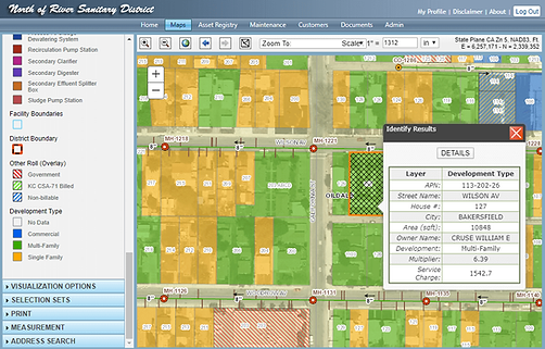
Your asset records are your GIS
In AIMS, a pipe, manhole, valve or hydrant is one record, viewable in a grid or on the map, with its full history, photos and documents attached. No syncing a GIS copy with an asset copy, and no second system to keep up to date. Crews complete inspections and maintenance in ArcGIS Field Maps, and the results flow straight back into AIMS.
Who it's for
Sanitary and sewer districts · Water districts · Stormwater programs · City public works · Wastewater treatment plants · Regional and joint-powers agencies. AIMS is used every day by field crews and supervisors, engineering and GIS staff, customer service, and managers reporting to their boards.
Every agency starts with the core platform and adds modules as it grows. AIMS is configured and supported by the people who built it, hosted by us or on your own servers.


Our Services
Esri Partner Network member

AIMS is built on Esri's ArcGIS platform, and AIMS Team is a member of the Esri Partner Network. We work together with Esri to help small utilities put enterprise GIS to work, from the geodatabase and map services to Field Maps for crews. You get GIS and asset management that fit together from day one.
“AIMS has opened the door on our collection system GIS to every member of staff.”
— District Engineer, California sanitary district



Contact
Let's talk
Call or email us for a live demo.
We'll walk through the modules that matter to your agency and talk through hosted or owned options and pricing.
510.427.0015
Mon-Fri, 9am-6pm PST
jpreiss@aimsteam.com
Mon-Fri, 9am-6pm PST
bottom of page